
Bard and Letz
Madriat
 Dogs allowed
Distance 10Km
Duration 3h00
Hiking route BOUCLE
Marking Yellow
In pictures
Route description
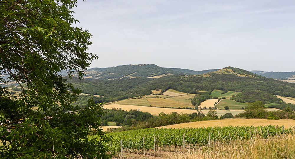
This not-to-be-missed walk will take you through the typical villages of the Lembronnais region, with their incredible red and ochre earth colors. You’ll also enjoy the AOC Côtes d’Auvergne Boudes vineyards.
Starting point – From the starting sign, attached to the common oven near the fountain, follow the D723 to the crossroads at the exit of Madriat. Take the D142, towards Boudes for 1.5 km (at the height of a dovecote, overlooking Nonnette, the Livradois mountains and the Boudes hills). After(…)
Trail highlights
– View of Nonette, the Livradois mountains and the Boudes hills.
– The Bard spring and its salt water.
– Red clay cliffs, Lembron, Avoiron and Montcelet peaks.
– The Mottes cirque.
Guidebook with maps/step-by-step
Step 1 : Follow the D723, leaving the four banal on your right. At the crossroads, just outside Madriat, take the D142 towards Boudes for 1.5 km (at the top of the hill, view of Nonette, the Livradois mountains and the Boudes hillsides). After a small bridge, continue for 150 m until you come to a track on the left.
Step 2 : Take this and immediately turn right to reach the village of Bard. Cross the bridge and continue as far as the communal oven ; go around it and turn left into rue de la Fontaine. At the T-junction, turn right, then immediately left. At the end of the village, go straight up a wide track (off the circuit, on the right, 5-minute round trip to the Bard Roman spring). At the crossroads, continue uphill to the left until you reach a carriage road.
Step 3 : Turn left (view of Lembron, Livradois, Forez summit, Pic de l’Avoiron, Pic de Montcelet). Continue to the crossroads at the entrance to the hamlet of Brugère-Basse.
Step 4 : Turn right, then immediately left (fortified farmhouse and remarkable buildings), go around the last house and straight ahead on a wide track. Ford a stream and keep right as far as Letz. Cross the road and take the passage between the houses. At the T-junction, turn right. The path bends left at a watering hole. Continue straight ahead to the communal oven (château).
Next step
Step 5 : Turn left down the road, then immediately right. After 400 m, leave the road and turn left onto the Chemin de Soullouzes. Go downhill, ignoring the left-hand paths. At the first T-junction, turn right, and at the second, fork left as far as the village of Madriat to get back to the starting point.
Proposed and managed by the Conseil départemental du Puy-de-Dôme – PDIPR.
Opening hours
From 01/01 to 31/12 daily.
Subject to favorable weather.
Comfort, facilities and services
- Pets welcome
Additional information
For your own safety, always take a bottle of water, a hat, warm clothing and footwear suitable for walking.
Depending on weather conditions, certain itineraries are not recommended in bad weather (fog) or are not practicable, or even forbidden, during the winter season.
Some sites are fragile, so stay on the marked trails. Avoid picking wild flowers and disturbing wildlife. Pick up your garbage.
Animals are not allowed on some routes.
Dogs allowed Dogs must be kept on a leash due to the presence of herds.
Environment
In the country, Presence of livestock and guard dogs
Access
South of Issoire on the A75 freeway, take exit 15 for Saint-Germain-Lembron, then inside the village turn right onto the D214 for Ardes. After 4 km, turn right at Madriat.
Downloadable :
Photo credits : Julie Lobstein
 Updated on 29 May 2026 by Conseil départemental du Puy-de-Dôme