
The Butte de Montaigut
Reignat
 Dogs allowed
Distance 7Km
Duration 2h15
Hiking route BOUCLE
Marking Yellow
In pictures

Route description
The architectural beauty of Reignat’s village fort, with its walls of blond arkoses and red tiles, makes this walk worthwhile, as do the panoramic views over the Chaîne des Puys, the Livradois and the castles of Auteras and Ravel.
Trail highlights
– View of the Turlurons and Billom, Montmorin, Mauzun and Ravel castles and the Forez mountains.
– Return trip to the orientation table.
Guidebook with maps/step-by-step
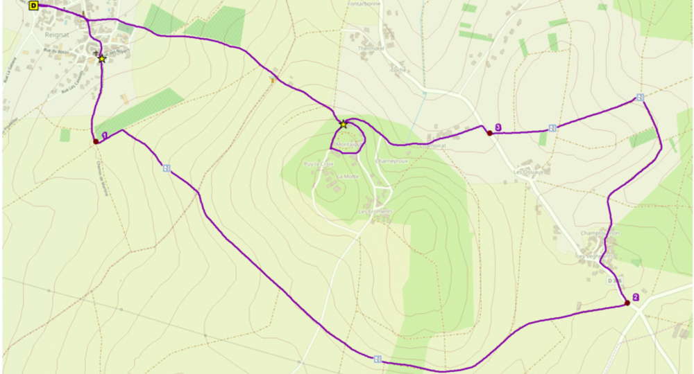
Step 1 : Place du puits. Enter Reignat and turn right into the square. At the wash-house, turn right. At the fountain, turn left and, 20 m further on, go right. Continue straight ahead on the road, then on the path (with a view of the Turlurons and Billom on the right, the Château de Montmorin opposite and the Forez mountains in the background). Take the second path on the left at the crossroads of 4 paths. At the next crossroads, turn right and continue straight ahead until you reach the road.
Step 2 : Cross the road and continue straight ahead (view of Mauzun castle opposite). At the D306, turn left into the hamlet of Les Vegheants. Take the first right. At the crossroads of 4 roads, continue straight ahead.
Step 3 : At the next crossroads (village of Glaine opposite : 2 km A-R ; view of Glaine in the foreground, the village of Ravel and its château in the background), turn left to reach the D306. Turn right for 20 m, then immediately left towards Chamoirat. Drive through Chamoirat, then turn left at a bend in the road. Under the remains of the château, take the first track on the left.
Step 4 : At the “patte d’oie” (opposite, A-R orientation table), turn right up the road. Just after the ruins, take the right-hand track. At the crossroads, go down to the left (view of Monts du Forez and Château de Ravel to the right, Thiers, Lezoux, Tour de Courcourt, Chaîne des Puys and Clermont-Ferrand opposite, Les Turlurons and Billom to the left). At the crossroads of 4 roads, continue straight ahead. At the entrance to Reignat, drive alongside the cemetery and continue straight ahead. At the square, continue straight ahead to reach the start.
Proposed and managed by the Conseil départemental du Puy-de-Dôme – PDIPR.
Opening hours
From 01/01 to 31/12 daily.
Subject to favorable weather.
Comfort, facilities and services
- Pets welcome
Additional information
For your own safety, always take a bottle of water, a hat, warm clothing and footwear suitable for walking.
Depending on weather conditions, certain itineraries are not recommended in bad weather (fog) or are not practicable, or even forbidden, during the winter season.
Some sites are fragile, so stay on the marked trails. Avoid picking wild flowers and disturbing wildlife. Pick up your garbage.
Animals are not allowed on some routes.
Dogs allowed Dogs must be kept on a leash due to the presence of herds.
Environment
In the country, Mountain view, Presence of livestock and guard dogs
Access
From Billom, take the D229 towards Lezoux. After 4 km, turn right towards Reignat.
Photo credits : Conseil départemental du Puy-de-Dôme, OpenStreetMap / Conseil départemental du Puy-de-Dôme
 Updated on 29 May 2026 by Conseil départemental du Puy-de-Dôme