![]()
Roche d’Agoux
Vergheas
 Dogs allowed
Distance 17Km
Duration 5h15
Hiking route BOUCLE
Marking Green
In pictures


Route description
Roche d’Agoux is an outcrop of quartz vein with a 360° view.
Trail highlights
– The Agnoux rock and its 360° view.
– The church at Vergheas (with the Virgin in Majesty)
– House of the royal notaries
– View of the village of Vergheas.
– Small heritage sites : hydraulic sawmill, mill, botanical garden, wash-house and mills.
Guidebook with maps/step-by-step
Step 1 : From the start sign below the chevet of the Vergheas church (12th-century church with Virgin in Majesty, Maison des notaires royaux PP1), take the D80 towards Biollet. At the last house, turn right towards Chapelle de la Vierge. At the stone cross, take the left-hand path. At the first fork (50 m), continue left to the next fork.
Step 2 : Go left downhill to the road. Turn left, then immediately right to cross the Viergne. Cross the stream and turn right (interesting buildings, hydraulic sawmill, mill, PP2 botanical garden). At the end of the hamlet, follow signs for Le Bois. Continue uphill (view of Vergheas), through a beech forest to a road.
Step 3 : Turn right, then 50 m further on, take a left-hand track lined with low walls, to another road. Turn left as far as Roche d’Agoux. Continue left on the D103 to Rocher d’Agoux (on the quartz boulder, 360° view PV1). Pass an old lime tree. At the village exit sign, take a right to a road. Turn left. At the first fork in the road, keep right until you reach a high-voltage power line.
Step 4 : Take the left-hand track to a crossroads with a meadow surrounded by forest. Go right down to the Grange du Bois farm. At the road, go left for 100 m. At a shed, turn right onto a track. At the first crossroads, turn left to Le Cheix. Cross the D517, and 50 m further on, turn left onto a track as far as a crossroads (under a power line).
Next step
Step 5 : Go left up to Saint-Maurice-près-Pionsat. At the iron cross, cross the D521 then the D988 towards Saint-Maurice center. Drive down the road between the war memorial and the wash-house, to the village exit. Continue down the left-hand path. Go up towards Villeboucheix to the D988 (lake, picnic area).
Step 6 : Follow this road to the right for 300m. Turn left onto a path between two field entrances. Pass a house and come to a road. Turn right for 20 m, then right onto a wide track (panoramic view of the Combrailles PV2) and continue to a road.
Step 7 : Turn left twice and go right for 500 m to an intersection. Turn left up the track leading to La Viade and take the tarmac road on the left. Stay on the road to the right. After the last house, take the track on the right. At the end of the shady lane, turn right to Villefubert. At the crossroads, turn right to Moulin d’en Bas. Turn left. Drive past the mill (Moulin Rome). Follow the road for 150 m and turn left onto a track leading to Vergheas.
Proposed and managed by the Conseil départemental du Puy-de-Dôme – PDIPR.
/* col-6_sm-12 */ ?>
Opening hours
All year round daily.
Subject to favorable weather.
Comfort, facilities and services
- Pets welcome
Additional information
For your own safety, always take a bottle of water, a hat, warm clothing and footwear suitable for walking.
Depending on weather conditions, certain itineraries are not recommended in bad weather (fog) or are not practicable, or even forbidden, during the winter season.
Some sites are fragile, so stay on the marked trails. Avoid picking wild flowers and disturbing wildlife. Pick up your garbage.
Animals are not allowed on some routes.
Dogs allowed Dogs must be kept on a lead due to the presence of herds.
Environment
In the country, Forest location, Mountain view, Presence of livestock and guard dogs
Access
To Vergheas, 65 km north-west of Clermont-Ferrand, via Pontaumur and Biollet
Downloadable :
You might also like…
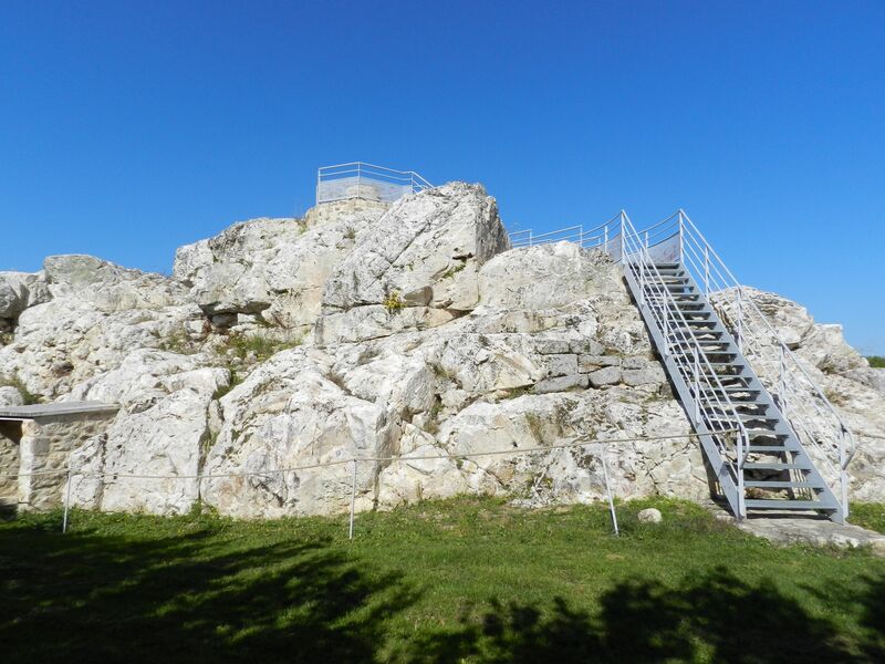
Photo credits : Elyas Saens, Office de Tourisme des Combrailles, Elyas Saens